


|
|
|
|
|
 |
 |
|
|
|
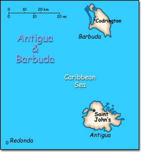
Official Name: Antigua and Barbuda Location: Caribbean, islands between the Caribbean Sea and the North Atlantic Ocean, east-southeast of Puerto Rico. Capital: Saint John's
Lowest point: Caribbean Sea 0 m Highest point: Boggy Peak 402 m |
|
||||||||||||
|
Population: 91,295 (July 2014 est.) Nationality: Antiguan(s), Barbudan(s) Ethnic groups: Black 91%, mixed 4.4%, Caucasian 1.7%, other 2.9% Religions: Protestant 76.4% (Anglican 25.7%, Seventh-Day Adventist 12.3%, Pentecostal 10.6%, Moravian 10.5%, Methodist 7.9%, Baptist 4.9%, Church of God 4.5%), Roman Catholic 10.4%, other Christian 5.4%, other 2%, none or unspecified 5.8% Languages: English (official), local dialects. |
|
Tropical marine with little seasonal temperature variation |
|
Government type: Constitutional monarchy with a parliamentary system of government and a Commonwealth realm Independence: 1 November 1981 (from the United Kingdom) National holiday: Independence Day (National Day), 1 November (1981) |

