


|
|
|
|
|
 |
 |
|
|
|
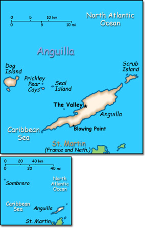
Official Name: Anguilla Location: Caribbean, islands between the Caribbean Sea and North Atlantic Ocean, east of Puerto Rico. Capital: The Valley
Lowest point: Caribbean Sea 0 m Highest point: Crocus Hill 65 m |
|
||||||||||||
|
Population: 16,086 (July 2014 est.) Nationality: Anguillan(s) Ethnic groups: Black (predominant) 90.1%, mixed, mulatto 4.6%, Caucasian 3.7%, other 1.5% Religions: Protestant 83.1% (Anglican 29%, Methodist 23.9%, other Protestant 30.2%), Roman Catholic 5.7%, other Christian 1.7%, other 5.2%, none or unspecified 4.3% Languages: English (official). |
|
Tropical, moderated by northeast trade winds |
|
Government type: Overseas territory of the United Kingdom Independence: None (overseas territory of the United Kingdom) National holiday: Anguilla Day, 30 May (1967) |

