


|
|
|
|
|
 |
 |
|
|
|
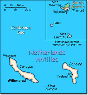
Official Name: Netherlands Antilles Location: Caribbean, two island groups in the Caribbean Sea - one includes Curacao and Bonaire north of Venezuela; the other is east of the Virgin Islands. Capital: Willemstad, Curaçao Island
Lowest point: Caribbean Sea 0 m Highest point: Mount Scenery 862 m |
|
||||||||||||
|
Population: 223,652 (July 2007 est.) Nationality: Dutch Antillean(s) Ethnic groups: Mixed black 85%, Carib Amerindian, white, East Asian. Religions: Roman Catholic, Protestant, Jewish, Seventh-Day Adventist. Languages: Dutch (official), Papiamento (a Spanish-Portuguese-Dutch-English dialect) predominates, English widely spoken, Spanish. |
|
Tropical, ameliorated by northeast trade winds |
|
Government type: Parliamentary Independence: None (part of the Kingdom of the Netherlands) National holiday: Queen's Day (Birthday of Queen-Mother Juliana in 1909 and accession to the throne of her oldest daughter Beatrix in 1980), 30 April |

