


|
|
|
|
|
 |
 |
|
|
|
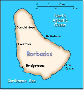
Official Name: Barbados Location: Caribbean, island in the North Atlantic Ocean, northeast of Venezuela. Capital: Bridgetown
Lowest point: Atlantic Ocean 0 m Highest point: Mount Hillaby 336 m |
|
||||||||||||
|
Population: 289,680 (July 2014 est.) Nationality: Barbadian(s) or Bajan (colloquial) Ethnic groups: Black 92.4%, white 2.7%, mixed 3.1%, East Indian 1.3%, other 0.2% Religions: Protestant 66.3% (includes Anglican 23.9%, other Pentecostal 19.5%, Adventist 5.9%, Methodist 4.2%, Wesleyan 3.4%, Nazarene 3.2%, Church of God 2.4%, Baptist 1.8%, Moravian 1.2%, other Protestant .8%), Roman Catholic 3.8%, other Christian 5.4% (includes Jehovah's Witness 2.0%, other 3.4%), Rastafarian 1%, other 1.5%, none 20.6% Languages: English (official), Bajan (English-based creole language, widely spoken in informal settings) |
|
Tropical. Rainy season from June to October |
|
Government type: Parliamentary Democracy and a Commonwealth realm Independence: 30 November 1966 (from the United Kingdom) National holiday: Independence Day, 30 November (1966) |

