


|
|
|
|
|
 |
 |
|
|
|
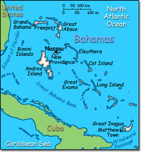
Official Name: Commonwealth of The Bahamas Location: Caribbean, chain of islands in the North Atlantic Ocean, southeast of Florida, northeast of Cuba. Capital: Nassau on New Providence Island
Lowest point: Atlantic Ocean 0 m Highest point: Mount Alvernia, on Cat Island 63 m |
|
||||||||||||
|
Population: 321,834 (July 2014 est.) Nationality: Bahamian(s) Ethnic groups: Black 90.6%, white 4.7%, black and white 2.1%, other 1.9% Religions: Protestant 69.9% (includes Baptist 34.9%, Anglican 13.7%, Pentecostal 8.9% Seventh Day Adventist 4.4%, Methodist 3.6%, Church of God 1.9%, Brethren 1.6%), Roman Catholic 12%, other Christian 13% (includes Jehovah's Witness 1.1%), other 0.6%, none 1.9% Languages: English (official), Creole (among Haitian immigrants). |
|
Tropical marine, moderated by warm waters of the Gulf Stream |
|
Government type: Constitutional Parliamentary Democracy and a Commonwealth realm Independence: 10 July 1973 (from the United Kingdom) National holiday: Independence Day, 10 July (1973) |

