


|
|
|
|
|
 |
 |
|
|
|
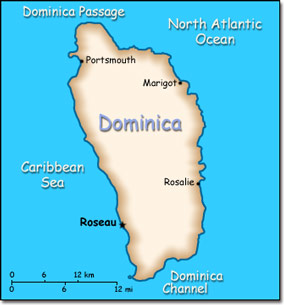
Official Name: Commonwealth of Dominica Location: Caribbean, island between the Caribbean Sea and the North Atlantic Ocean, about half way between Puerto Rico and Trinidad and Tobago. Capital: Roseau
Lowest point: Caribbean Sea 0 m Highest point: Morne Diablotins 1,447 m |
|
||||||||||||
|
Population: 73,449 (July 2014 est.) Nationality: Dominican(s) Ethnic groups: Black 86.8%, mixed 8.9%, Carib Amerindian 2.9%, white 0.8%, other 0.7% Religions: Roman Catholic 61.4%, Protestant 20.6% (Seventh-Day Adventist 6%, Pentecostal 5.6%, Baptist 4.1%, Methodist 3.7%, Church of God 1.2%), Jehovah's Witnesses 1.2%, other Christian 7.7%, Rastafarian 1.3%, other or unspecified 1.6%, none 6.1% Languages: English (official), French patois. |
|
Tropical. Moderated by northeast trade winds. Heavy rainfall |
|
Government type: Parliamentary democracy Independence: 3 November 1978 (from the United Kingdom) National holiday: Independence Day, 3 November (1978) |

