


|
|
|
|
|
 |
 |
|
|
|
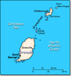
Official Name: Grenada Location: Caribbean, island between the Caribbean Sea and Atlantic Ocean, north of Trinidad and Tobago. Capital: Saint George's
Lowest point: Caribbean Sea 0 m Highest point: Mount Saint Catherine 840 m |
|
||||||||||||
|
Population: 110,152 (July 2014 est.) Nationality: Grenadian(s) Ethnic groups: Black 82%, mixed black and European 13%, European and East Indian 5%, and trace of Arawak/Carib Amerindian Religions: Roman Catholic 53%, Anglican 13.8%, other Protestant 33.2%. Languages: English (official), French patois. |
|
Tropical. Tempered by northeast trade winds |
|
Government type: Parliamentary Democracy and a Commonwealth realm Independence: 7 February 1974 (from the United Kingdom) National holiday: Independence Day, 7 February (1974) |

