


|
|
|
|
|
 |
 |
|
|
|
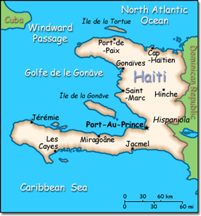
Official Name: Republic of Haiti Location: Caribbean, western one-third of the island of Hispaniola, between the Caribbean Sea and the North Atlantic Ocean, west of the Dominican Republic. Capital: Port-au-Prince
Lowest point: Caribbean Sea 0 m Highest point: Chaine de la Selle 2,680 m |
|
||||||||||||
|
Population: 9,996,731 (July 2014 est.) Nationality: Haitian(s) Ethnic groups: Black 95%, mulatto and white 5% Religions: Roman Catholic 80%, Protestant 16% (Baptist 10%, Pentecostal 4%, Adventist 1%, other 1%), none 1%, other 3%. Roughly half of the population also practices Voodoo Languages: French (official), Creole (official) |
|
Tropical. Semiarid where mountains in east cut off trade winds |
|
Government type: Republic Independence: 1 January 1804 (from France) National holiday: Independence Day, 1 January (1804) |

