


|
|
|
|
|
 |
 |
|
|
|
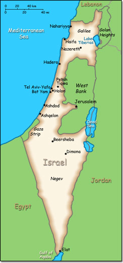
Official Name: State of Israel Location: Middle East, bordering the Mediterranean Sea, between Egypt and Lebanon. Capital: Jerusalem
Lowest point: Dead Sea -408 m. Highest point: Har Meron 1,208 m. |
|
||||||||||||
|
Population: 7,821,850 (July 2014 est.) Nationality: Israeli(s) Ethnic groups: Jewish 75.1% (of which Israel-born 73.6%, Europe/America/Oceania-born 17.9%, Africa-born 5.2%, Asia-born 3.2%), non-Jewish 24.9% (mostly Arab) Religions: Jewish 75.1%, Muslim 17.4%, Christian 2%, Druze 1.6%, other 3.9% Languages: Hebrew (official), Arabic (used officially for Arab minority), English (most commonly used foreign language) |
|
Temperate. Hot and dry in the southern and eastern desert areas |
|
Government type: Parliamentary democracy Independence: 14 May 1948 (from League of Nations mandate under British administration) National holiday: Independence Day, 14 May (1948); note - Israel declared independence on 14 May 1948, but the Jewish calendar is lunar and the holiday may occur in April or May |

