


|
|
|
|
|
 |
 |
|
|
|
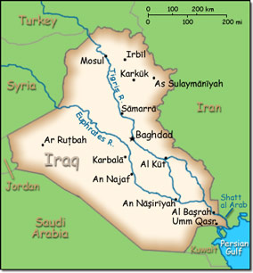
Official Name: Republic of Iraq Location: Middle East, bordering the Persian Gulf, between Iran and Kuwait. Capital: Baghdad
Lowest point: Persian Gulf 0 m. Highest point: Cheekha Dar (Kurdish for "Black Tent") 3,611 m |
|
||||||||||||
|
Population: 32,585,692 (July 2014 est.) Nationality: Iraqi(s) Ethnic groups: Arab 75%-80%, Kurdish 15%-20%, Turkoman, Assyrian or other 5%. Religions: Muslim (official) 99% (Shia 60%-65%, Sunni 32%-37%), Christian 0.8%, Hindu < .1, Buddhist < .1, Jewish < .1, folk religion < .1, unafilliated .1, other < .1 Languages: Arabic (official), Kurdish (official), Turkmen (a Turkish dialect) and Assyrian (Neo-Aramaic) are official in areas where they constitute a majority of the population), Armenian |
|
Mostly desert. Mild to cool winters with dry, hot, and cloudless summers. The northern mountainous regions along the Iranian and Turkish borders experience cold winters with occasionally heavy snows that melt in early spring, sometimes causing extensive flooding in central and southern Iraq |
|
Government type: Republic Independence: 3 October 1932 (from League of Nations mandate under British administration). 28 June 2004 the Coalition Provisional Authority transferred sovereignty to the Iraqi Interim Government National holiday: Republic Day, July 14 (1958) |

