


|
|
|
|
|
 |
 |
|
|
|
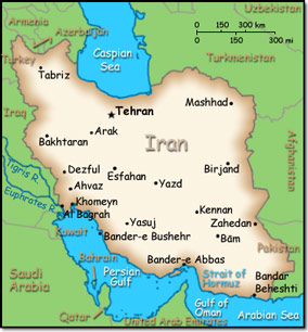
Official Name: Islamic Republic of Iran Location: Middle East, bordering the Gulf of Oman, the Persian Gulf, and the Caspian Sea, between Iraq and Pakistan Capital: Tehran
Lowest point: Caspian Sea -28 m Highest point: Kuh-e Damavand 5,671 m |
|
||||||||||||
|
Population: 80,840,713 (July 2014 est.) Nationality: Iranian(s) Ethnic groups: Persian 61%, Azeri 16%, Kurd 10%, Lur 6%, Baloch 2%, Arab 2%, Turkmen and Turkic tribes 2%, other 1% Religions: Muslim (official) 99.4% (Shia 90-95%, Sunni 5-10%), other (includes Zoroastrian, Jewish, and Christian) 0.3% Languages: Persian (official) 53%, Azeri Turkic and Turkic dialects 18%, Kurdish 10%, Gilaki and Mazandarani 7%, Luri 6%, Balochi 2%, Arabic 2%, other 2% |
|
Mostly arid or semiarid. Subtropical along the Caspian coast |
|
Government type: Theocratic Republic Independence: 1 April 1979 (Islamic Republic of Iran proclaimed) National holiday: Republic Day, 1 April (1979) |

