


|
|
|
|
|
 |
 |
|
|
|
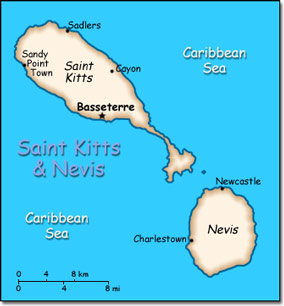
Official Name: Federation of Saint Kitts and Nevis Location: Caribbean, islands in the Caribbean Sea, about one-third of the way from Puerto Rico to Trinidad and Tobago. Capital: Basseterre on St. Christopher Island
Lowest point: Caribbean Sea 0 m Highest point: Mount Liamuiga 1,156 m |
|
||||||||||||
|
Population: 39,349 (July 2007 est.) Nationality: Kittitian(s), Nevisian(s) Ethnic groups: Predominantly black some British, Portuguese, and Lebanese. Religions: Anglican, other Protestant, Roman Catholic. Languages: English. |
|
Tropical tempered by constant sea breezes. Little seasonal temperature variation. Rainy season from May to November |
|
Government type: Constitutional monarchy with Westminster-style parliament Independence: 19 September 1983 (from the United Kingdom) National holiday: Independence Day, 19 September (1983) |

