


|
|
|
|
|
 |
 |
|
|
|
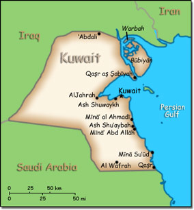
Official Name: State of Kuwait Location: Middle East, bordering the Persian Gulf, between Iraq and Saudi Arabia. Capital: Kuwait City
Lowest point: Persian Gulf 0 m Highest point: unnamed location 306 m |
|
||||||||||||
|
Population: 2,742,711 (July 2014 est.) Nationality: Kuwaiti(s) Ethnic groups: Kuwaiti 31.3%, other Arab 27.9%, Asian 37.8%, African 1.9%, other 1.1% (includes European, North American, South American, and Australian) Religions: Muslim (official) 76.7%, Christian 17.3%, other and unspecified 5.9% Languages: Arabic (official), English widely spoken |
|
Dry desert. Intensely hot summers. Short cool winters |
|
Government type: Constitutional emirate Independence: 19 June 1961 (from the United Kingdom) National holiday: National Day, 25 February (1950) |

