


|
|
|
|
|
 |
 |
|
|
|
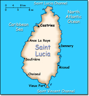
Official Name: Saint Lucia Location: Caribbean, island between the Caribbean Sea and North Atlantic Ocean, north of Trinidad and Tobago. Capital: Castries
Lowest point: Caribbean Sea 0 m Highest point: Mount Gimie 950 m |
|
||||||||||||
|
Population: 170,649 (July 2007 est.) Nationality: Saint Lucian(s) Ethnic groups: Black 90%, mixed 6%, East Indian 3%, white 1%. Religions: Roman Catholic 90%, Protestant 7%, Anglican 3%. Languages: English (official), French patois. |
|
Tropical, moderated by northeast trade winds. Dry season from January to April. Rainy season from May to August |
|
Government type: Westminster-style parliamentary democracy Independence: 22 February 1979 (from the United Kingdom) National holiday: Independence Day, 22 February (1979) |

