


|
|
|
|
|
 |
 |
|
|
|
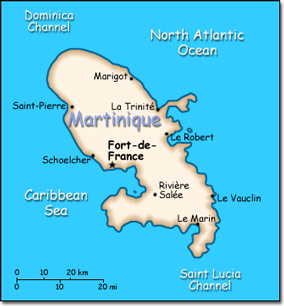
Official Name: Department of Martinique Location: Caribbean, island in the Caribbean Sea, north of Trinidad and Tobago. Capital: Fort de France
Lowest point: Caribbean Sea 0 m Highest point: Montagne Pelee 1,397 m |
|
||||||||||||
|
Population: 429,510 (July 2004 est.) Nationality: Martiniquais (singular and plural) Ethnic groups: African and African-white-Indian mixture 90%, white 5%, East Indian, Chinese less than 5%. Religions: Roman Catholic 95%, Hindu and pagan African 5%. Languages: French, Creole patois. |
|
Tropical, moderated by trade winds. Rainy season from June to October. Vulnerable to devastating cyclones (hurricanes) every eight years on average. Average temperature 17.3 degrees C. Humid |
|
Government type: Overseas department of France Independence: None (overseas department of France) National holiday: Bastille Day, 14 July (1789) |

