


|
|
|
|
|
 |
 |
|
|
|
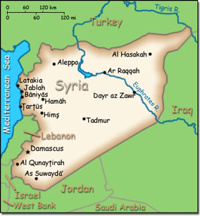
Official Name: Syrian Arab Republic Location: Middle East, bordering the Mediterranean Sea, between Lebanon and Turkey. Capital: Damascus
Lowest point: unnamed location near Lake Tiberias -200 m. Highest point: Mount Hermon 2,814 m. |
|
||||||||||||
|
Population: 19,314,747 (July 2007 est.) Nationality: Syrian(s) Ethnic groups: Arab 90.3%, Kurds, Armenians, and other 9.7%. Religions: Sunni Muslim 74%, Alawite, Druze, and other Muslim sects 16%, Christian (various sects) 10%, Jewish (tiny communities in Damascus, Al Qamishli, and Aleppo). Languages: Arabic (official); Kurdish, Armenian, Aramaic, Circassian widely understood; French, English somewhat understood. |
|
Mostly desert. Hot dry sunny summers from June to August and mild rainy winters from December to February along the coast. Cold weather with snow or sleet periodically hitting Damascus |
|
Government type: Republic under military regime since March 1963 Independence: 17 April 1946 (from League of Nations mandate under French administration) National holiday: Independence Day, 17 April (1946) |

