


|
|
|
|
|
 |
 |
|
|
|
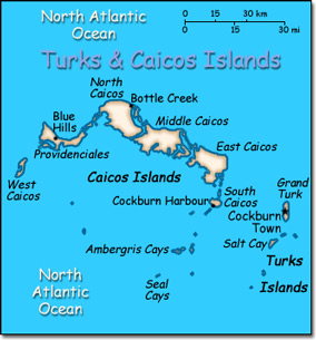
Official Name: Turks and Caicos Islands Location: Caribbean, two island groups in the North Atlantic Ocean, southeast of The Bahamas. Capital: Cockburn Town on Grand Turk Island
Lowest point: Caribbean Sea 0 m Highest point: Blue Hills 49 m |
|
||||||||||||
|
Population: 21,746 (July 2007 est.) Nationality: none Ethnic groups: Black. Religions: Baptist 40%, Methodist 16%, Anglican 18%, Church of God 12%, other 14%. Languages: English (official). |
|
Tropical marine, moderated by the trade winds. Sunny and relatively dry |
|
Government type: Overseas territory of the United Kingdom Independence: None (overseas territory of the the United Kingdom) National holiday: Constitution Day, 30 August (1976) |

