


|
|
|
|
|
 |
 |
|
|
|
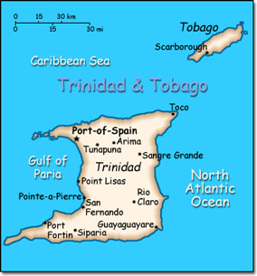
Official Name: Republic of Trinidad and Tobago Location: Caribbean, islands between the Caribbean Sea and the North Atlantic Ocean, northeast of Venezuela. Capital: Port of Spain
Lowest point: Caribbean Sea 0 m Highest point: El Cerro del Aripo 940 m |
|
||||||||||||
|
Population: 1,056,608 (July 2007 est.) Nationality: Trinidadian(s), Tobagonian(s) Ethnic groups: Black 39.5%, East Indian (a local term - primarily immigrants from northern India) 40.3%, mixed 18.4%, white 0.6%, Chinese and other 1.2%. Religions: Roman Catholic 29.4%, Hindu 23.8%, Anglican 10.9%, Muslim 5.8%, Presbyterian 3.4%, other 26.7%. Languages: English (official), Hindi, French, Spanish, Chinese. |
|
Tropical. Rainy season from June to December |
|
Government type: Parliamentary democracy Independence: 31 August 1962 (from the United Kingdom) National holiday: Independence Day, 31 August (1962) |

