


|
|
|
|
|
 |
 |
|
|
|
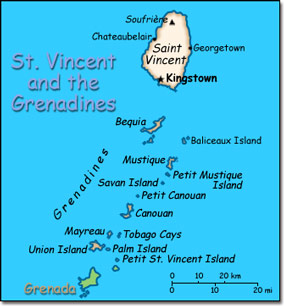
Official Name: Saint Vincent and the Grenadines Location: Caribbean, islands in the Caribbean Sea, north of Trinidad and Tobago. Capital: Kingstown
Lowest point: Caribbean Sea 0 m Highest point: Soufriere 1,234 m |
|
||||||||||||
|
Population: 118,149 (July 2007 est.) Nationality: Saint Vincentian(s) or Vincentian(s) Ethnic groups: Black 66%, mixed 19%, East Indian 6%, Carib Amerindian 2%, other 7%. Religions: Anglican 47%, Methodist 28%, Roman Catholic 13%, Hindu Seventh-Day Adventist, other Protestant. Languages: English, French patois. |
|
Tropical. Little seasonal temperature variation. Rainy season from May to November |
|
Government type: Parliamentary democracy; independent sovereign state within the Commonwealth Independence: 27 October 1979 (from the United Kingdom) National holiday: Independence Day, 27 October (1979) |

