


|
|
|
|
|
 |
 |
|
|
|
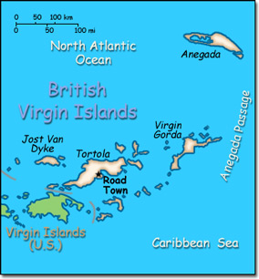
Official Name: British Virgin Islands Location: Caribbean, between the Caribbean Sea and the North Atlantic Ocean, east of Puerto Rico. Capital: Road Town on Tortola Island
Lowest point: Caribbean Sea 0 m Highest point: Mount Sage 521 m |
|
||||||||||||
|
Population: 32,680 (July 2014 est.) Nationality: British Virgin Islander(s) Ethnic groups: Black 82%, white 6.8%, other 11.2% (includes Indian and mixed) Religions: Protestant 84% (Methodist 33%, Anglican 17%, Church of God 9%, Seventh-Day Adventist 6%, Baptist 4%, other 15%), Roman Catholic 10%, Jehovah's Witnesses 2%, other 2%, none 2% Languages: English (official). |
|
Subtropical. Humid. Temperatures moderated by trade winds |
|
Government type: NA Independence: None (Overseas Territory of the United Kingdom) National holiday: Territory Day, 1 July (1956) |

