


|
|
|
|
|
 |
 |
|
|
|
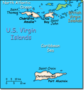
Official Name: United States Virgin Islands Location: Caribbean, islands between the Caribbean Sea and the North Atlantic Ocean, east of Puerto Rico. Capital: Charlotte Amalie on St. Thomas Island
Lowest point: Caribbean Sea 0 m Highest point: Crown Mountain 474 m |
|
||||||||||||
|
Population: 108,448 (July 2007 est.) Nationality: Virgin Islander(s) Ethnic groups: Black 80%, white 15%, other 5%. Religions: Baptist 42%, Roman Catholic 34%, Episcopalian 17%, other 7%. Languages: English (official), Spanish, Creole. |
|
Subtropical, tempered by easterly trade winds. Relatively low humidity with little seasonal temperature variation. Rainy season from May to November |
|
Government type: Organized, unincorporated territory of the United States Independence: None (organized, unincorporated territory of the United States) National holiday: Transfer Day (from Denmark to the US), 27 March (1917) |

